Geogo Webinar Rewatch
Transcript from the webinar:
Geogo Webinar
Hosted by Oaka Books
Speaker 1: Simon Lewis (IAPS Geography Advisor and former Chief Setter for ISEB 13+ Common Entrance Papers)
Speaker 2: Harry (Co-founder of Oaka Books)
[Speaker 2 – Harry]:
Okay, I think we can make a start. I’ll try to let anyone else in who joins during the presentation. Good afternoon, everyone. My name is Harry, and I’m co-founder of Oaka Books. I’d like to formally welcome you to our webinar.
For those of you who aren’t familiar with us, Oaka Books specializes in producing learning resources for visual and dyslexic learners, as well as children with special educational needs. Today’s webinar will focus on map reading, a crucial skill for young learners, and we’ll be introducing Geogo, a fantastic game to encourage children to develop these skills in a fun and inclusive way. Whether at home, in a scout or guide group, or in the classroom, Geogo is designed to make map reading both fun and engaging for everyone.
We’re thrilled to have Simon Lewis with us today, who is the IAPS Geography Advisor and former Chief Setter of the ISEB 13+ Common Entrance Papers for Geography. Simon brings a wealth of experience, and I’m sure you’ll find his insights valuable. The webinar will last around 30 to 45 minutes and will be recorded, and we’ll send it out afterwards.
We encourage you to ask questions—please send them in via chat, and we’ll do our best to answer them at the end of the presentation. If questions come to you after the webinar, feel free to email them, and we’ll respond to you.
With that, I’ll hand over to Simon. Simon, take it away!
[Speaker 1 – Simon Lewis]:
Thank you, Harry, and good afternoon to everyone in this webinar. Thanks for taking the time to join us.
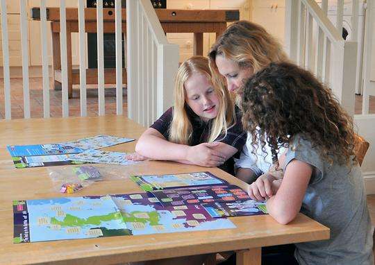
As Harry mentioned, Geogo is a game I developed while teaching in the classroom. It’s a fun way to learn and consolidate map-reading skills. The game was launched in 2019 as a kinesthetic and socially interactive tool to help develop Ordnance Survey map-reading skills using a colorful board and actual map extracts of Britain. Geogo is a board game that can be played both at home and in schools or scout groups. It’s designed for 2-4 players, and scout groups and Duke of Edinburgh participants often praise it as the perfect wet-weather activity to build confidence in map reading.
In 2020, Geogo was awarded a Silver Medal by the Geographical Association for its contribution to geographical learning.
So, what does Geogo aim to do? Primarily, it builds confidence and competence in Ordnance Survey map-reading. The game helps players master familiar maps, either in paper format or digitally on phones and tablets. The Ordnance Survey produces two main scales of maps: the 1:25,000 scale, which is great for walking and cycling, and the 1:50,000 scale, which is more general.
Through Geogo, we aim to build geographical literacy. Once you’ve mastered the skills, you can read any Ordnance Survey map of Britain, interpret the symbols, and get a feel for the landscape even before arriving. It’s like a type of reading—decoding the symbols that Ordnance Survey uses.
The game also promotes oracy—something the new government is keen to push in schools. As players communicate while playing the game, they build map-reading skills and interpersonal skills. There’s also a focus on fair play, which encourages students to think about being fair and kind to other players.
Geogo also highlights the diverse landscape in Britain, with map extracts chosen to reflect both rural and urban settings. It’s essentially kinesthetic learning—learning by doing—which, in my 37 years of classroom experience, is the best kind of learning. You can come from behind and win, but even if you don’t, you will have reinforced key map-reading skills.
The game board is colorful and designed in a familiar style, similar to Monopoly. Players move around the board by rolling dice, and the game isn’t burdened by complicated rules. It’s logical, progressing through five core map-reading skills: symbol recognition, directions, distances, grid references, and relief.
Each Geogo game comes with Ordnance Survey keys for map symbols, which players can refer to during the game. The game can be played by anyone, regardless of whether they’ve learned map reading before. Players can use the key or play without it if they’re more advanced.
The five core map-reading skills are complemented by five applied skills: identifying features on the map like landforms, settlements, transport routes, industry, and land use. These skills help players apply their basic map-reading knowledge to understand what’s on the map.
The aim of the game is to collect reward tokens by answering questions correctly. Players need to gather a variety of tokens from different map-reading categories, and the winner is the one who reaches the Ordnance Survey HQ square on the board with the required number of tokens.
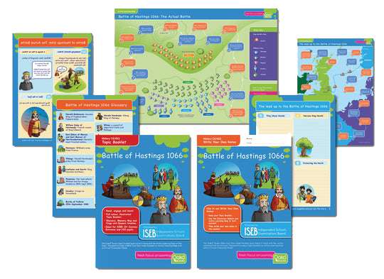
The game comes with actual Ordnance Survey map extracts at two scales: 1:25,000 and 1:50,000. The main set includes extracts from Liverpool, Hereford, the Mumbles in South Wales, and Aviemore in Scotland, giving players a geographic spread and a mix of urban and rural settings.
There’s also a Geogo expansion pack, which includes more maps and cards, including a focus on central London. This is a great option for players who want to explore different areas.
In 2020, Geogo received a Silver Award from the Geographical Association, and we’re very proud of that recognition.
Now, I’d love to hear your thoughts on the game. Please send in any questions you have.
[Speaker 2 – Harry]:
Simon, we seem to be having a technical issue with the chat, so if you can’t submit your questions there, please email them to us at [email protected]. We’ve had a question emailed in asking about the recommended age, group sizes, and the time it takes to play the game.
[Speaker 1 – Simon Lewis]:
Geogo is primarily aimed at Year 6 pupils, so that’s 10- and 11-year-olds, but it can certainly go into lower secondary and beyond. It’s fun for anyone, including adults, but it’s most suitable for those who have already been introduced to map reading. Without prior knowledge, players might find it difficult, especially when it comes to grid references.
The game is designed for 2-4 players. When I’ve used it in the classroom, I’ve allowed students to pick their own groups. If you’re planning to play with a larger group, it might be useful to have multiple sets of the game, and Harry can explain any bulk buying options.
[Speaker 2 – Harry]:
We’ve had another question about using Geogo with larger groups, such as scout or guide groups. How would you recommend playing the game in those settings?
[Speaker 1 – Simon Lewis]:
In larger settings, I recommend breaking players into smaller groups of up to four, which helps keep everyone engaged. If possible, set up tables and chairs in a bigger room or divide the space into smaller areas so that multiple groups can play at once. The game works well as an indoor activity for scouts, guides, or Duke of Edinburgh participants, especially as a wet-weather option.
[Speaker 2 – Harry]:
Another question came in about whether map-reading skills are still relevant in today’s world, given the changes in geography syllabuses and the rise of digital tools like Google Maps.
[Speaker 1 – Simon Lewis]:
Map reading is still an intrinsic part of geography. It’s more than just a skill for geography—it’s a life skill. If you can read an Ordnance Survey map, you’ll be able to navigate and understand maps from anywhere in the world. While digital maps like Google Maps are popular, they aren’t a replacement for traditional map-reading skills. You can’t always rely on your phone, especially if you lose signal or run out of battery, so knowing how to read a physical map is a valuable skill.
In my role with the Geography Review, I’m advocating for more emphasis on map reading in GCSEs and A-levels. Geography is the science of location, and map reading is at the heart of that. It’s a survival skill, and although it might not be as popular as it once was, I believe it will come full circle.
[Speaker 2 – Harry]:
One more question: what’s the highest age or educational level Geogo is suitable for?
[Speaker 1 – Simon Lewis]:
That depends on the student’s background and how much map reading they’ve already learned. Geogo can be fun for anyone, even undergraduates. It’s designed to be enjoyable for all levels because it teaches players about areas they might not know. It’s ideal for Year 6 students but can go up to secondary levels and be a great tool for reinforcing map-reading skills, especially for GCSE preparation. Even A-level students can benefit from the game if they’re studying a particular area like London. It can also be fun for adults who want to brush up on their map-reading skills.